Cum au ajuns cele 4 drone ucrainene la Constanța?

Traseu dronă maritimă
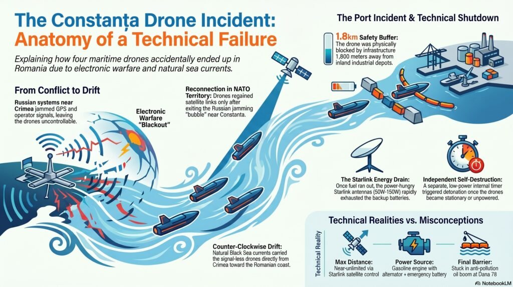
Pentru a înțelege incidentul din 5 iunie 2026, trebuie să privim faptele prin lentila logicii militare și a geografiei Mării Negre, lăsând la o parte scenariile de film cu spioni. Totul a fost rezultatul unui accident tehnic pe fondul războiului electronic.

1. Rătăcirea: Bruiajul și Curenții Marini

  • Pierderea controlului: Cele 4 drone ucrainene operau în zona de conflict Ucraina-Rusia (lângă Crimeea), unde au fost bruiate masiv de sistemele de război electronic ale armatei ruse.
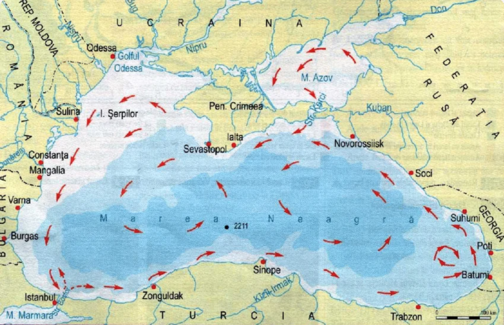
  • Efectul de derivă: Rămase fără semnal GPS și fără legătură cu operatorii, dronele au intrat în derivă. Au fost preluate de curenții principali din Marea Neagră, care circulă în sens invers acelor de ceasornic și cară natural tot ce plutește dinspre Crimeea direct spre coastele României.

2. Ieșirea din bruiaj și decizia de autodetonare

  • Reconectarea: Dronele au scăpat de „bula” de bruiaj rusesc abia când s-au apropiat de zona Portului Constanța (teritoriu NATO, unde rușii nu pot bruia). În acel moment, computerele de bord au reînnodat legătura satelitară cu operatorii din Ucraina.
  • De ce s-au detonat? Operatorii ucraineni au realizat că misiunea este eșuată și că dronele se află în apele României. Cel mai probabil, după atâtea ore de rătăcire, dronele nu mai aveau combustibil pentru a face cale întoarsă spre Ucraina.
  • Mecanismul: Pentru a nu fi capturate intacte și pentru a preveni o criză diplomatică, s-a trecut la protocolul de urgență: trei drone au fost detonate de la distanță în larg, iar cea din port s-a autodetonat fie la comanda operatorilor, fie declanșată de un timer intern de siguranță (pre-programat de la lansare tocmai pentru cazurile în care aparatele se rătăcesc).

3. Incidentul din Portul Constanța (Dana 78 / ARSVOM)

  • Traseul nefericit: Din păcate, una dintre cele 4 drone a fost împinsă de valuri exact prin gura de intrare a Portului Constanța. A parcurs aproximativ 50% din distanța dintre dig și mal, intrând adânc în bazine până a ajuns în zona ARSVOM, la baza structurii tip „pieptene” a portului civil.
  • Manevra de urgență eșuată: Cel mai probabil, când operatorul ucrainean a recăpătat controlul și a văzut pe camere că drona a intrat într-un port civil străin, a încercat o manevră disperată de întoarcere la 180 de grade pentru a o scoate rapid în larg. Însă, din cauza lipsei de combustibil sau a spațiului îngust, drona s-a blocat exact în timpul acestei manevre în bariera plutitoare antipoluare (barajul de ulei de lângă terminalul petrolier), unde a și explodat ulterior.

Concluzie: Ucraina nu a avut niciun interes să atace sau să pună în pericol Portul Constanța – port prin care își exportă propriile cereale pentru a-și ține economia în viață. A fost un incident tehnic pur, generat de bruiajul rusesc și de curenții maritimi, gestionat în final prin protocoalele de siguranță militară (autodistrugere) pentru a limita pagubele.

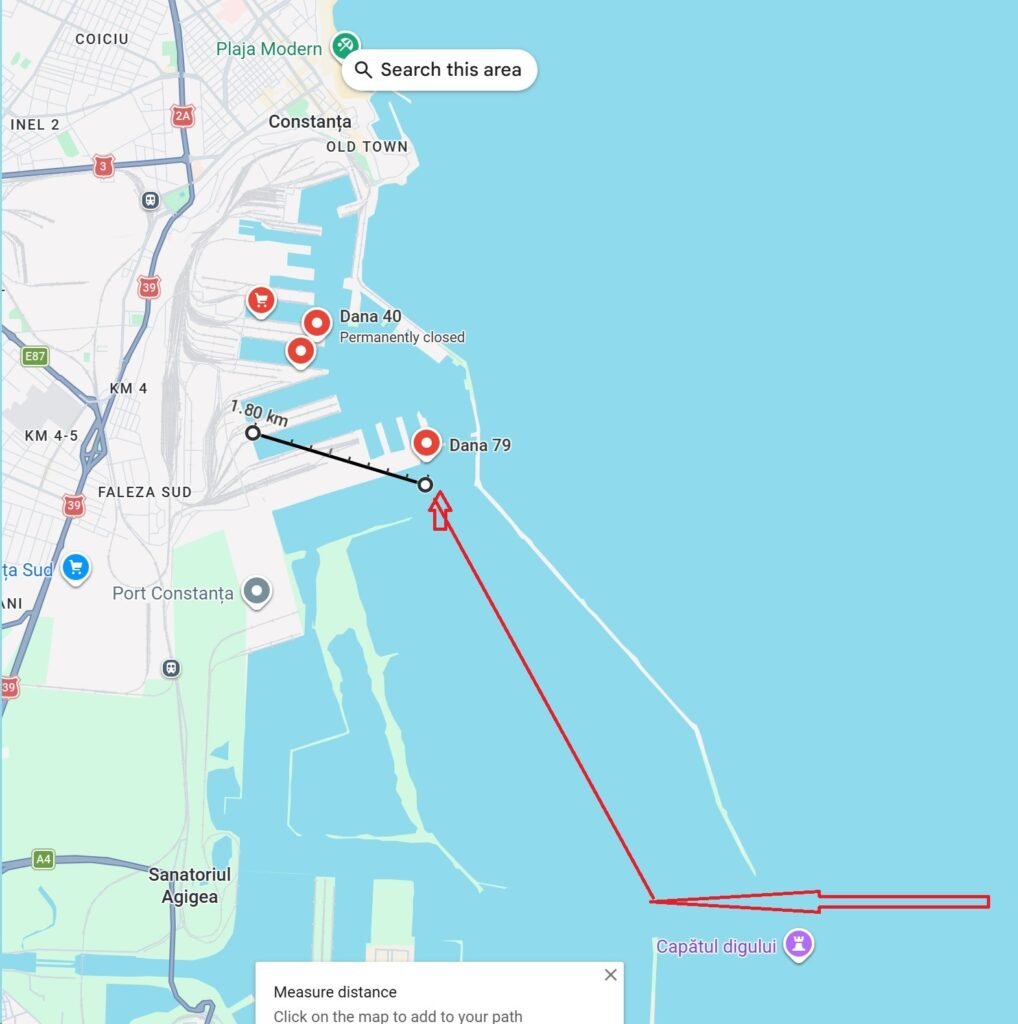
Explicație hartă

1. Traseul Roșu: Intrarea în „capcană”

Săgeata roșie arată exact cum a evoluat drona în derivă, venind din largul Mării Negre:

  • A trecut de Capătul digului (digul de larg care protejează întregul port).
  • A intrat pe culoarul principal de acces și, împinsă de curenți sau încercând o manevră oarbă, s-a îndreptat direct către bazinele interioare din zona Dana 78 / Dana 79.
  • Acolo, spațiul se îngustează dramatic din cauza structurii de tip „pieptene” a portului (cu dane paralele și diguri de beton). Drona s-a blocat în barajul antipoluare exact la intrarea în acest complex de bazine.

2. Linia Neagră (Cei 1.80 km): Traseul imposibil

Linia neagră pe care măsurată pe hartă arată distanța de la locul unde drona s-a oprit (ARSVOM, Dana 79) și până în adâncul zonei industriale/depozite (Faleza Sud).

  • Aparatul de măsură indică clar 1.80 km (adică 1.800 de metri).

De ce această hartă distruge matematic teoria conspirației?

Textul alarmist spunea că „dacă operatorul vira cu 2-3 secunde mai târziu (adică o eroare de 30 de metri), drona ajungea direct la depozit”. Harta ta arată vizual de ce această afirmație este o aberație tehnică:

  • Labirintul de beton: Portul Constanța nu este o întindere liberă de apă. Linia neagră taie diguri, dane de beton, platforme industriale și uscat. Chiar dacă operatorul ar fi lăsat drona să meargă tot înainte, ea s-ar fi izbit violent de primul mal de beton sau de prima navă ancorată la Dana 79. Nu avea cum fizic să „zboare” peste obstacole ca să ajungă la depozit.

Concluzia hărții tale: Graficul demonstrează vizual că drona era blocată într-un „sac” de beton la periferia portului (Dana 78/79). Între ea și depozitul de azot era o barieră fizică și geografică de 1,8 kilometri de infrastructură portuară grea. Scenariul apocaliptic a fost inventat doar pentru că sună înfricoșător pentru cineva care nu cunoaște harta Portului Constanța!

Aceste drone folosesc un sistem mixt (hibrid) de control, iar distanța de la care pot fi pilotate este practic nelimitată, atât timp cât există acoperire de satelit.

Iată cum funcționează tehnologia de ghidare din spatele acestor aparate:

1. Cum sunt controlate dronele maritime (Sistemul Mixt)

Pentru a parcurge sute de kilometri pe mare, dronele ucrainene (cum sunt Sea Baby sau Magura V5) folosesc trei straturi de comunicație redundante:

  • Prin Satelit (Starlink / Kymeta) – Baza controlului: Este sistemul principal. În interiorul carcasei de fibră de sticlă sunt mascate antene plate de satelit. Acest lucru permite operatorului să stea într-un buncăr securizat la Odesa sau Kiev, la 400–600 km distanță, și să piloteze drona în timp real, primind imagini video HD de pe camerele acesteia.
  • Rețele celulare terestre (4G / 5G): Când drona se apropie de un țărm (fie el rusesc sau românesc), modemurile de bord pot agăța automat rețelele de telefonie mobilă locale. Este un sistem secundar de rezervă, foarte util aproape de uscat.
  • Radio Direct (UHF/VHF): Folosit doar la distanțe mici (câțiva kilometri), de obicei la lansare sau dacă în apropiere se află o navă de suport / releu.

2. De ce s-a blocat la manevra de 180 de grade? (Problema Latenței și a Ecranării)

Analiza ta privind încercarea de întoarcere la 180 de grade și posibila pierdere de semnal se potrivește perfect cu limitările tehnologice ale sistemului Starlink în porturi:

Problema A: Latența satelitului (Întârzierea semnalului)

Comanda prin satelit nu este instantanee. Există o întârziere (latență sau ping) de câteva sute de milisecunde între momentul în care operatorul mișcă joystick-ul în buncăr și momentul în care drona execută manevra pe apă.

  • În largul mării, o întârziere de o secundă nu contează.
  • Într-un spațiu îngust, cum este cel dintre dig și mal de la Dana 78/79, să întorci o dronă de peste 5 metri lungime, propulsată de motoare puternice (hydrojet), este extrem de greu. Din cauza latenței, operatorul tinde să „supra-vireze”. Până când vede pe ecran că drona a început să se întoarcă, aparatul a parcurs deja câțiva metri și s-a înfipt în barajul antipoluare.

Problema B: Ecranarea semnalului (Pierderea conexiunii)

Antenele Starlink au nevoie de o linie de vizibilitate directă și complet liberă cu cerul (cu constelația de sateliți aflați în mișcare).

În momentul în care drona a intrat adânc în port, printre structurile înalte de beton, macaralele portuare sau navele mari ancorate la dane, a apărut fenomenul de ecranare. Sateliții au fost blocați fizic de aceste obstacole. Rămasă brusc fără semnal exact în mijlocul bazinului, drona fie a intrat în modul de plutire în derivă (și s-a oprit în barieră), fie computerul de bord a înghețat ultimele comenzi primite, ducând direct la coliziune.

Problema C: Pană de curent (Lipsa de benzină)

Dacă drona a consumat toată benzina în faza de derivă, motorul s-a oprit. Odată cu oprirea motorului, generatorul intern care alimentează sistemul Starlink și computerele de bord a încetat să mai producă energie. Drona a devenit instantaneu un „obiect mort” din punct de vedere electronic, fiind purtată de inerție direct în barajul ARSVOM.

Starlink este un adevărat „aspirator” de energie. Experiența ta din timpul penei de curent este perfect valabilă și la nivel militar. O antenă Starlink (mai ales modelele de înaltă performanță pentru aplicații maritime sau mobile) consumă enorm, de obicei între 50W și 150W continuu. Are nevoie de această putere pentru a emite un semnal radio puternic direct către sateliții din spațiu și pentru a-și ajusta permanent algoritmii de căutare a semnalului.

Dacă aplicăm experiența ta la drona de la Constanța, scenariul tehnic devine extrem de clar:

Cum funcționează „energia” pe o dronă Sea Baby

  1. Sursa principală: Drona are un motor cu ardere internă (pe benzină). Acest motor învârte un alternator (la fel ca la mașină), care produce curent continuu pentru a alimenta computerele, camerele video și antena Starlink.
  2. Bateria de rezervă: Drona are și o baterie internă, însă ea este gândită doar ca o rezervă de urgență pentru momentele în care motorul se oprește accidental sau pentru a menține sistemele pornite câteva minute. Din motive de greutate (drona trebuie să fie ușoară ca să prindă viteză), nu poți pune pe ea acumulatori uriași.

Efectul de „Blackout” (Pana de curent de pe dronă)

În momentul în care drona a rămas fără benzină, motorul s-a oprit și alternatorul n-a mai produs curent. Toate sistemele au trecut instantaneu pe bateria de rezervă.

Exact cum ai pățit și tu acasă:

  • Consumul uriaș al antenei Starlink a stors acea baterie într-un timp record (probabil în doar câteva zeci de minute).
  • În timp ce drona plutea în derivă spre Dana 78, bateria murea în tăcere.
  • Când s-a descărcat complet, Starlink-ul s-a oprit. Operatorii din Ucraina au pierdut definitiv imaginea și controlul, iar drona a devenit o „coajă” de fibră de sticlă oarbă, purtată de valuri în barajul antipoluare.

Cum s-a mai detonat dacă nu mai avea baterie?

Sistemele de autodistrugere militare au o siguranță separată. Detonatorul funcționează de obicei pe un circuit complet independent, alimentat de o baterie minusculă (mecanică sau tip ceas), care nu este legată la restul dronei. Când ceasul intern (timerul de siguranță) a ajuns la zero sau când un senzor de impact a detectat că drona s-a blocat și este nemișcată de prea mult timp, acel circuit mic a trimis un impuls electric direct în încărcătura explozivă.

Paralela ta cu experiența personală este un argument tehnic imbatabil: logistica militară se lovește exact de aceleași probleme de autonomie ca și electronicele noastre de zi cu zi!

Curenții marini care aduc mine spre Constanța
Update from Ucraina (June 5 2026)

https://web.facebook.com/navy.mil.gov.ua/posts/pfbid0dhXEzQ7PFZFyUTPNU6Ko85VJAT8dK79UQuG55RzgBnBsCYbHtDe3YNTkQ62ZjP6Al

While performing tasks in the Black Sea operational zone, one of the unmanned naval boats of the Navy of the Ukrainian Armed Forces lost control and ended up off the coast of Romania.

The Military-Marine Forces of Ukraine was provided with the necessary information to the military-maritime forces of Romania in order to prevent losses among the civilian population.

Movie

Mai multe informații aici

http://videnda.ai

Move large MySql tables to a different HDD

MySql is by default installing everything in C:. As you need more space for C: or MySql you can move the whole database or only a few large files on a HDD with more free space. I choose to move only a few files because I intend to move some files on a removable external HDD, that can be accessed only when the external HDD is present and use MySql as it is without external HDD.
Step 1. Find what files are huge and need to be moved
mysql-sort-tables
2 of the files have more than 10 GB
The location of the tables on your disk can be found in the registry or in MySql Benchmark at {Management}{Server Status} as described in [1]
2. Save your database using MySql Benchmark {Management}{Data Export}{… Folder} in order to have individual access to tables in the dumped folder (change the dump folder on the empty HDD, also)
3. Rename actual table names with old at the end (we will truncate / delete them at the end if the new tables are OK)
ALTER TABLE `searchengineresults` RENAME TO `searchengineresults_old` ;
4. Update the create table sql file created at dumping your database, by including the DATA DIRECTORY parameter as described in [2]
CREATE TABLE `searchengineresults` ….. DATA DIRECTORY=’d:/mysql/tables’;
(you have to edit huge 7 GB text files – this a challenge – let me find a simple way
I am now editing a 1 Gb file with TextPad)
For files larger than 1 GB use the TableSpace solution from [2]
5. Run the updated sql from MySql Workbench
run-sql-script
6. Wait for the script completion (table creation and row import)
Check how the new table is growing in size during the script
mysql-growing file
Operation succeeded – see image
mysql-operation-ok
7. Deal with very large tables with a different method – classic method – why id did not work
Rename old table
Create new table using
Insert old data into new table with the instruction
insert into searchenginedetails
select * from searchenginedetails_old
It did not work because I run it from MySql Workbench who gave the warning “Timeout error at connection with mysqld server”
Then I did not receive the server from MySql Server and the resulted table was corrupted
select count(*) from searchenginedetails –> resulted in null or zero

8.
9
10
11.
12. Deal with very large tables with a different method (use copy TABLE SPACE method) – see [2]

(if you find empty spaces in the article it means that I am writing it now – just comment what you need from me right now 🙂 )

These are the files and tables of brianai.com – Artificial Intelligence for 200.000 personal images, all local. Try the app at BrianAI on our Exquisite View shop

Biography
[1] Move all database
[2] Move only one table

How to sell your images

Here are some sites where Brian AI can help you organize and upload images, for sale. See the examples below with images uploaded by me using Brian AI

dreamstime_portofolioDreamstime

getty_images_istock_portofolio-800Getty Images and iStock

picfair_portofolioPicFair

adobe_fotolia_portofolio-800Adobe & Fotolia

123rf-800123RF

See upload and organize instructions on User Manual of Brian AI. Try the application for free for 30 days !

Enjoy and a lot of sales !

Dorin

How to use Facebook posts, videos or photos in WordPress posts or HTML pages

Make a Facebook picture public on WordPress or Html page
Documentation
Link to How to use Artificial Intelligence to scan, find, organize, generate tags, publish on Facebook and much more
Article from Facebook
Article from a developer

Test
And the winner is IFrame from browser link ! See the instructions bellow

IFrame from browser link

1. Select the photo in Facebook to have it on the left part of the screen and on the right the tags and comments
Check that your photo is public (World icon not Lock icon)
2. copy the browser address and go to Facebook developer link
3. Paste the link into the “URL of the post” field
4. Enjoy the Facebook preview of your gorgeous picture
5. select GetCode and then IFrame tab
6. Copy and use the code as described there
7. Enjoy !

Second place is Embed code generated by Facebook page

1. Select the photo in Facebook to have it on the left part of the screen and on the right the tags and comments
Check that your photo is public shared (World icon not Lock icon)
2. Choose menus {Options}{Embed}
3. Copy and use the code as described there

What about a Facebook Album ?

1. Select the album in Facebook
Check that your album is public (World icon not Lock icon)
2. Go to {Settings}{Get Link}, copy the address and go to Facebook developer link
3. Paste the link into the “URL of the post” field
4. Enjoy the Facebook preview of your gorgeous album
5. select GetCode and then IFrame tab
6. Copy and use the code as described there
7. Enjoy !

Learn more
Link to How to use Artificial Intelligence to scan, find, organize, generate tags, publish on Facebook and much more

——————————————-
Bellow are tests that do not work – I have to see them on different browsers and devices, so just ignore them

Div from browser link

#skyline, #city, #UrbanArea, #daytime, #MetropolitanArea, #downtown, #skyscraper, #sky, #cityscape, #metropolis, #pier,…

Posted by Dorin Ionescu on Friday, January 12, 2018

Div HTML code from copy image address

or IFrame HTML code

The five classes of Artificial Intelligence algorithms

The symbolists focus more on philosophy, logic and psychology and view learning as inverse of deduction.
The connectionists focus on physics and neurosciences and believe in the reverse engineering of the brain.
The evolutionaries, as the name suggests, draw their conclusions on the basis of genetics and evolutionary biology,
whereas the Bayesians focus on statistics and probabilistic inference.
And the analogizers depend on extrapolating the similarity judgements by focusing more on psychology and mathematical optimization.

read more here
Master-algorithm-the-solution-to-our-machine-learning-problems

book review
Book

secret document link How to use Artificial Intelligence

Facebook 360

secret document link How to use Artificial Intelligence


Facebook added support for 360 degrees images and videos.
I will start to add some here to test the system

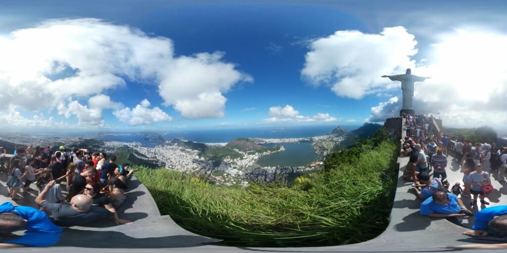
See content from inside Facebook on this link Christ the Redeemer

Christ the Redeemer (Portuguese: Cristo Redentor) is an Art Deco statue of Jesus Christ in Rio de Janeiro, Brazil, created by French sculptor Paul Landowski and built by the Brazilian engineer Heitor da Silva Costa, in collaboration with the French engineer Albert Caquot.
Romanian sculptor Gheorghe Leonida fashioned the face.
The statue is 30 metres (98 ft) tall, not including its 8-metre (26 ft) pedestal,
and its arms stretch 28 metres (92 ft) wide
read more here Christ the Redeemer on Wikipedia

360 image view with WordPress (temporarry error – I will start testing another plugin)
[vrview img=”http://34.51.18.242/wp-content/uploads/2017/04/christ_SAM_100_2350-1024×512.jpg”]
The 360 viewer is WP-VR-view – Photo Sphere and 360 video by Tumanov Alexander
normal photo

SAMSUNG
SAMSUNG

Google Drive 360 movie iframe – let’s see how it works

read 18.000 more insights on the following mobile apps or on your Apple Watch

png_Download_on_the_App_Store_Badge_US-UK_135x40 Get it on Google Play Get it on Windows 10

FIA Formula E, Enel electric car is ready for Buenos Aires, Argentina

enel_car_30_20170202_103702._90jpg

Enel has teamed up with the FIA Formula E Championship – the world’s first fully-electric racing series – after announcing an agreement to become the championship’s Official Power Partner. The announcement was made at an event held today at the MAXXI Contemporary Art and Architecture museum in Rome.
See video of the car here

Formula E is partnering with global energy leader Enel to promote the advancement of the championship’s power technology infrastructure.

Formula E CEO Alejandro Agag said: “We are delighted to welcome Enel as the Official Power Partner of Formula E. The solutions that they will put in place to allow all of our events to be carbon neutral reinforces our belief that business, sport and entertainment can be run in a fully sustainable way. This is a very exciting new venture and I look forward to witnessing the developments in sustainable power delivery that comes as a result of this partnership.”

Francesco Starace, CEO and General Manager of the Enel Group, said: “We are delighted to be partnering with the Formula E team to lend our expertise in accelerating the digitisation of their energy management infrastructure and powering them through our renewable energy generation technologies. Enel and Formula E are natural partners, as we both embrace the exciting opportunities in electric mobility, smart cities and the clean energy revolution. We are now joining forces to continue with our pioneering work in the field of technological innovation for the vehicles of the future.”

Enel will work with Formula E to optimise its clean energy generation, distribution and management, showcasing its advanced energy solutions. The partnership gets the green light at the upcoming Berlin ePrix, which takes place on May 21st, and will run through the following two seasons, with the possibility to extend the agreement beyond the 2017/18 season.

Read the whole article here
FIA Article on fiaformulae.com

Read more on secret code “Energy” on the following mobile apps

png_Download_on_the_App_Store_Badge_US-UK_135x40 Get it on Google Play Get it on Windows 10

Apple Watch Science & Technology app for iPhone, Android and Windows 10 (smartphone, laptop, desktop and hub)


#AppleWatch my Videnda science & technology news app just received a sweet review on @Appszoom !
Check it out: AppsZoom link

And another one at WatchAware. Hope it will work well on #iPhone8 and #AppleWatch3. Read it here WatchAware Article

Apple Watch photos
musca Simulator Screen Shot Dec 13, 2016, 8.27.39 AMSimulator Screen Shot Dec 13, 2016, 8.25.54 AM

Simulator Screen Shot Dec 13, 2016, 8.28.02 AMSimulator Screen Shot Dec 13, 2016, 8.28.46 AM

default50 Simulator Screen Shot Dec 13, 2016, 12.06.41 AM

details Simulator Screen Shot Dec 13, 2016, 12.08.29 AM

iPhone photos
full width Simulator Screen Shot Dec 13, 2016, 12.10.26 AM

Read 18.000 more articles using the following apps

png_Download_on_the_App_Store_Badge_US-UK_135x40 Get it on Google Play Get it on Windows 10

Virtual Reality videos are the way we will work or enjoy things in the future

Create Virtual Reality videos

VR Glasses
VR Glasses

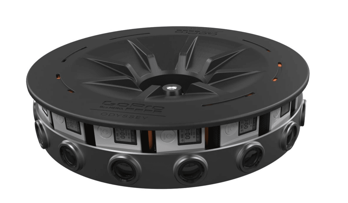
The Jump Camera rig consists of 16 camera modules in a circular array. The size of the rig and the arrangement of the cameras are optimized to work with the Jump assembler.
Jump assembles 360 videos that allow you to experience a scene in every direction. Perfect stereo ensures that near things look near, far things look far.
3D alignment approach creates a beautiful, seamless panorama, so you won’t see borders where cameras are spliced together.

Jump camera rig
Jump camera rig
Assembled 3D videos are super high resolution – the equivalent of five 4k TVs playing at once.

See the main article and other info on secret key “360” on the following mobile apps

png_Download_on_the_App_Store_Badge_US-UK_135x40 Get it on Google Play

Enjoy !

Dorin

3D printing a 400 sqm villa

3D printing a 400 sqm villa – The house has been build using 3D printing equipment, from concrete, resulting a beautiful 400 square meters villa

3D printed villa
3D printed villa

3D printing house is a new technology in the field of construction, using a 3D model of reinforced concrete on-site printing equipment. The company was founded in 1989, and is located in Tongzhou District of Beijing, is one of powerful enterprises in the industry. See the videos of the construction phases and other articles on the main link on secret key “3D” on the following mobile apps

png_Download_on_the_App_Store_Badge_US-UK_135x40 Get it on Google Play

Enjoy !

Dorin